

Look up the FEMA flood zone for a property
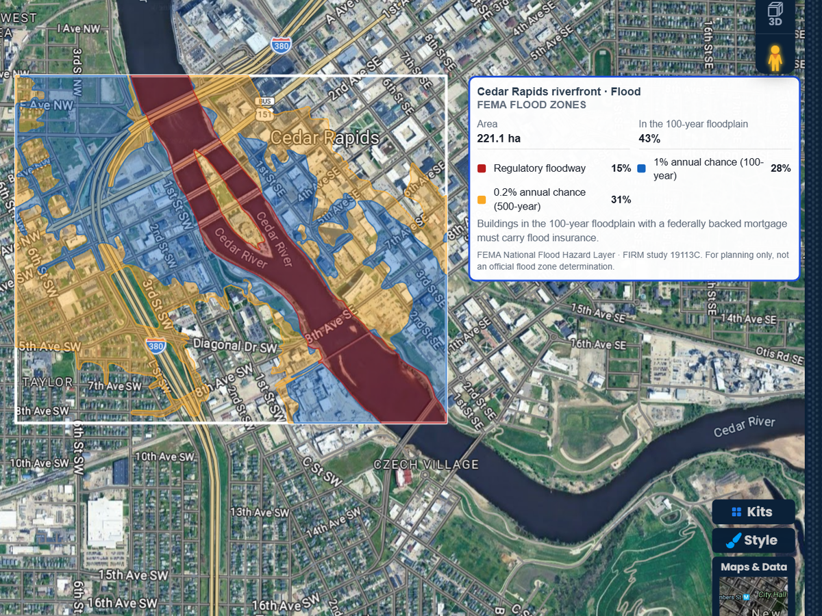
Find the address, outline the lot or the block, and read its FEMA flood zones. Each zone is drawn on the map and listed with its share of the area, its base flood elevation and the FIRM study it comes from.

 English
 Español
 Français
 Deutsch
 Português
 日本語
 中文
 العربية
 한국어
 Italiano
 Русский
 Türkçe
 Nederlands
 Polski
 हिन्दी
 Dansk
 Čeština
 Română
 Ελληνικά
 Tiếng Việt
 Suomi
 Українська
 Indonesia
 Svenska
 Norsk bokmål
 Hrvatski
 Magyar
 Български
 中文(繁體)
 Slovenčina
 Srpski
 ไทย
 Eesti
 Català
 Lietuvių
 עברית
 Slovenščina
 فارسی
 Latviešu
 Azərbaycan
 Беларуская
 Melayu
 Bosanski
 ქართული
 Shqip
 Gaeilge
 Монгол
 ဗမာ
 O‘zbek
 اُردو
 Македонски
 ខ្មែរ
 Nynorsk
 বাংলা
 Galego
 Euskara
 Íslenska
 தமிழ்
 ລາວ
 ગુજરાતી
 Latina
 मराठी
 Қазақ тілі
 ਪੰਜਾਬੀ
 Afrikaans
 नेपाली
 አማርኛ
 తెలుగు
 ChiShona
 Cymraeg
 Føroyskt
 অসমীয়া
 Brezhoneg
 Esperanto
 Basa Jawa
 کٲشُر
 Ирон
 Sardu
Chirca un'indiritzu, trassa sa propiedade o su bighinau, e otene sas zonas de allagamentu FEMA, sa piana inondàbile de 100 annos e sas artàrias base de allagamentu subra de sa mappa tua. A pustis trascina unu cursore pro artziare s'abba subra de unu terrenu detalladu. Sas primas 3 simulatziones tuas sunt gratuitas.
 4.7 / 5 · 200 retzensiones in G2
★ ★ ★ ★ ★“So un'agente immobiliare e custu software at fatu a manera chi siat fàtzile meda creare una mappa personalizàbile de cumpartzire cun sos clientes nostros pro mapare sos territòrios imbenientes nostros.”
See the floodway, the 100-year and 500-year floodplains, coastal high hazard areas and levee areas, each in its own color. The report shows how much of the area sits in the 100-year floodplain.
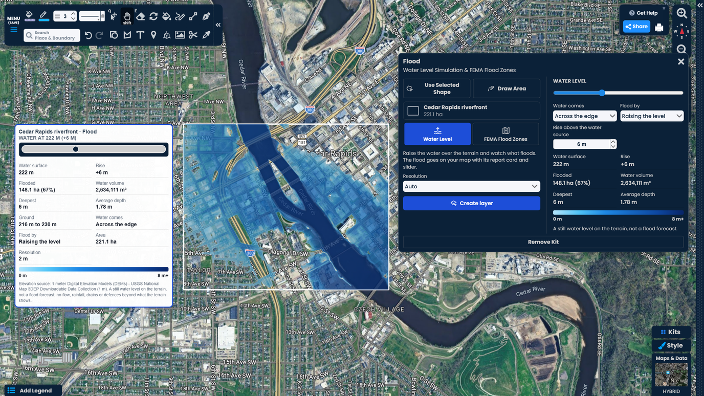
Drag one slider and the water climbs over the terrain right away. See which streets and lots go under first, how deep the water gets, and how much ground floods.
The flood zones and the water level go on your map with a report card. Share it by link with a client, a buyer or your team. No GIS software needed.
Find the address, outline the lot or the block, and read its FEMA flood zones. Each zone is drawn on the map and listed with its share of the area, its base flood elevation and the FIRM study it comes from.
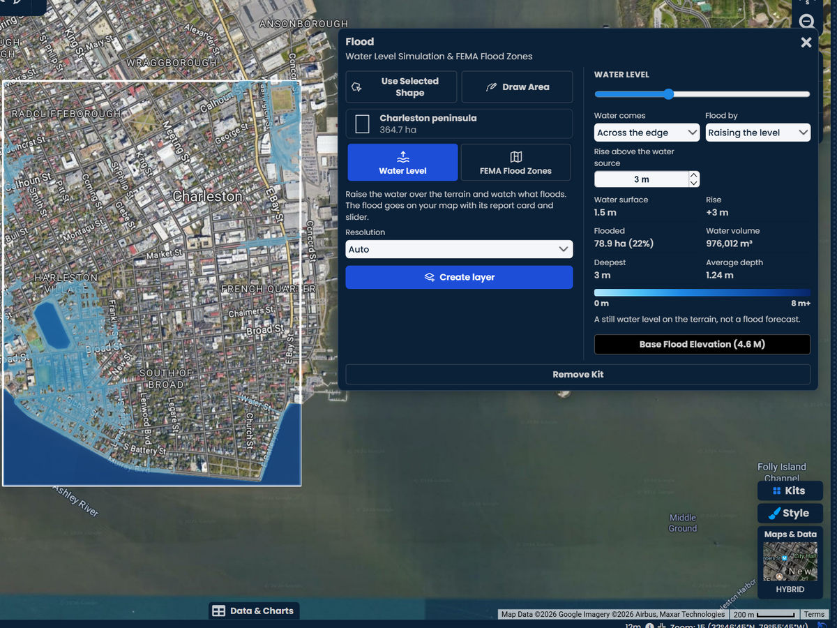
Move the slider to set the water level. The kit shows the flooded ground, the deepest point, the average depth, the water volume and the share of the area under water as you move it.
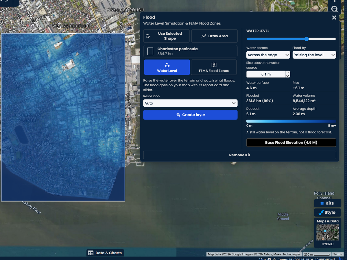
After you read the FEMA zones, one click sets the water to the highest base flood elevation FEMA lists for the area. See the ground that level would cover, lot by lot, on detailed terrain.
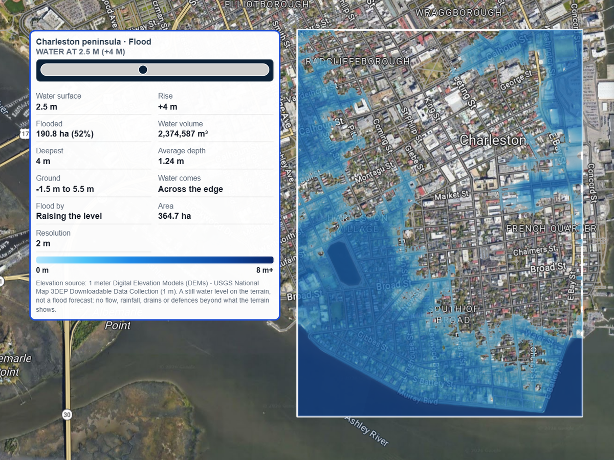
Let the water come in across the edge of the area, like a river or the sea at a set height, and raise it step by step. Or pick a marker where water enters, such as a creek or a drain, and watch it spread from there.
Scribble AI
Nàrrilli a Scribble AI su chi ti serbit. Pròba “disinna una zona de respetu de 500m inghìriu a cada situ,” “importa custu CSV e colòra pro istadu,” o “mìsura su percursu dae su depòsitu a cada fermada.” Ddu faghet in pagos segundos. Peruna formatzione GIS netzessària, e s'iscuadra tua retzit sa matessi mapa, pronta pro èssere cumpartzida.
Pròba Scribble AI →Pro Business
$100 per month
Aberi su kit Flood, chirca s'indiritzu e trassa sa propiedade o s'àrea a inghìriu a issa. Sèbera sas zonas de allagamentu FEMA e àvia sa simulatzione. Sas zonas benint disignadas subra de sa mappa, e su relatu elencat onzi zona, sa cuota sua de s'àrea e s'artària base de allagamentu sua.
Sas zonas benint dae su National Flood Hazard Layer de sa FEMA, sos datos a palas de sas mappas de allagamentu FEMA (FIRM). Su relatu nùmenat s'istùdiu FIRM dae ue benint sas zonas, de gasi ddu podes verificare cun sa mappa matessi de sa FEMA.
Nono. Est pro pianificatzione e chirca. Sos creditores e sos asseguradores impreant una determinatzione ufitziale de zona de allagamentu pro unu mùtuu o una pòlitza. Emprea Scribble Maps pro bìdere su riscu, ddu ispiegare a unu cliente e detzìdere in ue mirare cun prus atentzione.
Sas zonas chi comintzant cun A, comente AE, s'agatant in sa piana inondàbile de 100 annos: terrinu cun un'1% de probabilidade de allagamentu onzi annu. Sas zonas chi comintzant cun V, comente VE, sunt àreas costeras chi afrontant fintzas undas de tempesta. Zone X ombregiada est sa piana inondàbile de 500 annos, o terrinu amparadu dae un'àrghene. Zone X no ombregiada tenet unu perìgulu mìnimu de allagamentu. Su kit nùmenat onzi zona in paràulas craras.
Sos edifìtzios in sa piana inondàbile de 100 annos cun unu mùtuu garantidu a livellu federale depent àere un'asseguratzione contra sos allagamentos. Su relatu sinnalat cantu de s'àrea ruet in cussa piana inondàbile.
Su kit càrrigat su terrenu pro s'àrea tua una borta. Cando moves su cursore, s'abba prenada su terrinu chi podet sizire dae sa fonte sua, comente s'oru de s'àrea o unu sinnaladore chi sèberas tue. Est unu livellu de abba calma subra de su terrenu, no una prevididura idrològica de allagamentu: no modèllat sas pròias, sa velotzidade de su cursu, sos caladòrgios o sos muros contra sos allagamentos chi su terrenu no ammustrat.
Ea, comente livellu de abba calma. Lassa chi s'abba intret peri s'oru de un'àrea costera e àrtiala a s'artària chi cheres verificare. Sa mappa ammustrat cale terrinu s'agatat suta de cussu livellu e est collegadu a s'abba.
Sas zonas de allagamentu FEMA còverint sos Istados Unidos, mancari carchi contea no apat una mappa de allagamentu FEMA. Sa simulatzione de su livellu de s'abba funtzionat in cale si siat logu, subra de terrenu lidar de 1 m in bona parte de sos USA e terrenu de 30 m in sos àteros logos.
Onzi contu cun atzessu efetuadu retzit 3 simulatziones de allagamentu gratuitas. A pustis de custas, su kit Flood faghet parte de Pro Business, a $100 a su mese o $90 a su mese cun faturatzione annuale, cun una proa gratuita de 7 dies pro sos noos abbonados idòneos.